Kirovsky District, Primorsky Krai
Kirovsky District
Кировский район | |
|---|---|
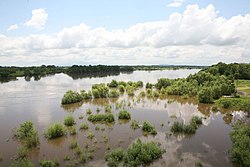
 Ussuri River, Kirovsky District | |
 Location of Kirovsky District in Primorsky Krai | |
| Coordinates: 45°0′0″N 133°40′0″E / 45.00000°N 133.66667°E | |
| Country | Russia |
| Federal subject | Primorsky Krai[1] |
| Established | 1935 |
| Administrative center | Kirovsky[2] |
| Area | |
• Total | 3,483.9 km2 (1,345.1 sq mi) |
| Population | |
• Total | 21,249 |
| • Density | 6.1/km2 (16/sq mi) |
| • Urban | 64.7% |
| • Rural | 35.3% |
| Administrative structure | |
| • Inhabited localities[1] | 2 Urban-type settlements[5], 25 rural localities |
| Municipal structure | |
| • Municipally incorporated as | Kirovsky Municipal District[6] |
| • Municipal divisions[6] | 2 urban settlements, 4 rural settlements |
| Time zone | UTC+10 (MSK+7 |
| OKTMO ID | 05612000 |
| Website | http://mo.primorsky.ru/kirovsky/ |
Kirovsky District (Russian: Ки́ровский райо́н) is one of the twenty-two administrative[1] and municipal[6] districts (raion) in Primorsky Krai, Russia. It is located in the west of the krai. The area of the district is 3,483.9 square kilometers (1,345.1 sq mi).[3] Its administrative center is the urban locality (an urban-type settlement) of Kirovsky.[2] Population: 21,249 (2010 Census);[4] 24,618 (2002 Census);[8] 29,516 (1989 Soviet census).[9] The population of the administrative center accounts for 42.6% of the district's total population.[4]
Geography
[edit]Forests occupy half of the district's territory. The highest temperature ever registered in Kirovsky District was 36.7 °C (98.1 °F), on July 23, 2021.[10]
Economy and tourism
[edit]Agriculture, beekeeping, and timber-cutting are considered to have potential.
Health resorts development dominates the economy of the district. Narzan-type Shmakovskiye mineral springs (hydrocarbonated and calcium-magnesium), with limpid water rich in carbonic acid, are well-known. Shmakovka is a unique health-center complex where is situated Imeni Pyatidesyatiletiya Oktyabrya Health Resort for three hundred people.
The district's landmarks include a tower-chapel located on one of the highest viewpoints of the Shmakovka Resort.
References
[edit]Notes
[edit]- ^ a b c Law #161-KZ
- ^ a b Государственный комитет Российской Федерации по статистике. Комитет Российской Федерации по стандартизации, метрологии и сертификации. №ОК 019-95 1 января 1997 г. «Общероссийский классификатор объектов административно-территориального деления. Код 05 212», в ред. изменения №278/2015 от 1 января 2016 г.. (State Statistics Committee of the Russian Federation. Committee of the Russian Federation on Standardization, Metrology, and Certification. #OK 019-95 January 1, 1997 Russian Classification of Objects of Administrative Division (OKATO). Code 05 212, as amended by the Amendment #278/2015 of January 1, 2016. ).
- ^ a b Официальный сайт Законодательного Собрания Приморского края. Сборник "Муниципальные образования Приморского края" (Official website of the Legislative Assembly of Primorsky Krai. Municipal Formations of Primorsky Krai) (in Russian)
- ^ a b c Russian Federal State Statistics Service (2011). Всероссийская перепись населения 2010 года. Том 1 [2010 All-Russian Population Census, vol. 1]. Всероссийская перепись населения 2010 года [2010 All-Russia Population Census] (in Russian). Federal State Statistics Service.
- ^ The count of urban-type settlements may include the work settlements, the resort settlements, the suburban (dacha) settlements, as well as urban-type settlements proper.
- ^ a b c Law #215-KZ
- ^ "Об исчислении времени". Официальный интернет-портал правовой информации (in Russian). June 3, 2011. Retrieved January 19, 2019.
- ^ Federal State Statistics Service (May 21, 2004). Численность населения России, субъектов Российской Федерации в составе федеральных округов, районов, городских поселений, сельских населённых пунктов – районных центров и сельских населённых пунктов с населением 3 тысячи и более человек [Population of Russia, Its Federal Districts, Federal Subjects, Districts, Urban Localities, Rural Localities—Administrative Centers, and Rural Localities with Population of Over 3,000] (XLS). Всероссийская перепись населения 2002 года [All-Russia Population Census of 2002] (in Russian).
- ^ Всесоюзная перепись населения 1989 г. Численность наличного населения союзных и автономных республик, автономных областей и округов, краёв, областей, районов, городских поселений и сёл-райцентров [All Union Population Census of 1989: Present Population of Union and Autonomous Republics, Autonomous Oblasts and Okrugs, Krais, Oblasts, Districts, Urban Settlements, and Villages Serving as District Administrative Centers]. Всесоюзная перепись населения 1989 года [All-Union Population Census of 1989] (in Russian). Институт демографии Национального исследовательского университета: Высшая школа экономики [Institute of Demography at the National Research University: Higher School of Economics]. 1989 – via Demoscope Weekly.
- ^ "31878: Kirovskij (Russia)". ogimet.com. OGIMET. July 23, 2021. Retrieved July 24, 2021.
Sources
[edit]- Законодательное Собрание Приморского края. Закон №161-КЗ от 14 ноября 2001 г. «Об административно-территориальном устройстве Приморского края», в ред. Закона №673-КЗ от 6 октября 2015 г. «О внесении изменений в Закон Приморского края "Об административно-территориальном устройстве Приморского края"». Вступил в силу со дня официального опубликования. Опубликован: "Красное знамя Приморья", №69 (119), 29 ноября 2001 г. (Legislative Assembly of Primorsky Krai. Law #161-KZ of November 14, 2001 On the Administrative-Territorial Structure of Primorsky Krai, as amended by the Law #673-KZ of October 6, 2015 On Amending the Law of Primorsky Krai "On the Administrative-Territorial Structure of Primorsky Krai". Effective as of the official publication date.).
- Законодательное Собрание Приморского края. Закон №215-КЗ от 29 декабря 2004 г. «О Кировском муниципальном районе», в ред. Закона №522-КЗ от 26 декабря 2014 г. «О внесении изменений в статью 4 Закона Приморского края "О Кировском муниципальном районе"». Вступил в силу с 1 марта 2005 г. Опубликован: "Ведомости Законодательного Собрания Приморского края", №84, 29 декабря 2004 г. (Legislative Assembly of Primorsky Krai. Law #215-KZ of December 29, 2004 On Kirovsky Municipal District, as amended by the Law #522-KZ of December 26, 2014 On Amending Article 4 of the Law of Primorsky Krai "On Kirovsky Municipal District". Effective as of March 1, 2005.).

